↓
 

York Land Surveying

Local Land Surveyors in York, ME

York Land Surveying
(207) 337-9088
York Land Surveying
  • Home
  • ALTA Survey
  • Boundary Surveying
  • Construction Survey
  • Drone LiDAR Mapping
  • Elevation Certificate
  • Land Surveying
  • Topographic Survey
  • Blog
  • Contact Us
Home - Page 2 << 1 2 3 4 … 7 8 >>

Post navigation

← Older posts
Newer posts →

Your Builder Will Ask for a Construction Survey. Here Is What That Means.

York Land Surveying Posted on June 2, 2026 by YorkSurveyorMay 28, 2026
Land surveyor performing a construction survey with staking markers at a residential home construction site

You have found your lot, hired your architect, and chosen your builder. Things are moving in the right direction. Then your builder mentions they need a construction survey before work can begin. If you are not sure what that means or why it matters, you are not alone. Most people hear this term for the first time at this exact moment in the building process.

Here is everything you need to know.

What Is a Construction Survey?

A construction survey is a service performed by a licensed land surveyor that takes the plans on paper and marks them out on the actual ground. It is sometimes called a construction stakeout or a staking survey. All three names mean the same thing.

When your architect designs a building, everything exists on a drawing. The foundation goes here. The driveway starts there. The utility connections land at this point. A construction survey takes all of those measurements and marks them physically on your property using stakes, flags, and markers. Your builder then uses those marks to build in exactly the right spot.

Without a construction survey, your builder would essentially be guessing where to put things. On a construction project, guessing leads to expensive mistakes.

Why Does Your Builder Need One?

Builders need a construction survey to know exactly where to place a structure on a property. It makes sure the building is positioned correctly according to the approved plans, stays within legal setback requirements, and does not accidentally cross property lines or encroach on easements.

Here is what can go wrong without one.

A building placed even a few feet in the wrong direction can violate local setback rules. Setbacks are the minimum distances required between a structure and a property line. Breaking those rules can result in fines, forced changes to the building, or in serious cases, tearing down part of the structure.

A misplaced foundation can also cross onto a neighbor’s property or land inside an easement area. Fixing either of those problems after concrete has already been poured is not a simple or cheap process.

According to the National Society of Professional Surveyors, construction placement errors caused by missing or inaccurate staking are among the most common and costly mistakes in both home and commercial building projects.

What Does a Construction Survey Include?

Construction surveyor reviewing staking plans and GPS layout data at an active residential building site

The scope of a construction survey depends on the size of the project. For a typical home build, it will generally cover the following.

  • Staking the corners of the building footprint directly on the ground
  • Marking setback lines from property boundaries as required by local zoning rules
  • Locating and marking easements that could affect where the building goes
  • Setting elevation benchmarks so the builder knows the correct height for the foundation
  • Staking the location of driveways, utilities, and other features shown on the plans
  • Providing a final check once construction is done to confirm everything was built as designed

Each stake and marker serves as a physical guide that keeps every phase of construction lined up with the approved plans.

When Does a Construction Survey Happen?

A construction survey happens in stages throughout the building process. The first stage takes place before any ground is broken. Additional surveys may follow at the foundation, framing, and completion stages depending on what the project requires.

A construction survey is not always a single visit. Larger projects may require the surveyor to come back at different points during construction.

Before the ground is broken. The surveyor stakes the building corners and key site features so the builder knows exactly where to dig and where to place everything.

At the foundation stage. The surveyor may return to check that the foundation forms are in the right position before concrete is poured. This is one of the most important checkpoints in the entire build.

During site work. More staking may be needed for utilities, drainage structures, or roads as the project moves forward.

At project completion. A final survey documents exactly where everything was built. This is often required by lenders, permit offices, and future buyers.

How Is a Construction Survey Different From Other Surveys?

It helps to understand how a construction survey fits in with the other surveys involved in a building project.

A boundary survey shows your property lines. It tells you where your land starts and ends. This is usually done first.

A topographic survey maps the shape of your land, including elevation changes, drainage patterns, and existing features. This is done before design work begins.

A construction survey takes the finished design and marks it on the ground so your builder knows exactly where to build.

Think of it this way. The boundary survey tells you what you own. The topographic survey tells you what it looks like. The construction survey tells your builder exactly where to put everything.

What Happens If You Skip the Construction Survey?

Some builders on smaller projects may suggest skipping the construction survey to cut costs. This is a shortcut that rarely works out well.

Here is what can happen if you skip it.

  • A building placed too close to a property line may fail the final inspection and need expensive changes
  • Foundation mistakes discovered after concrete is poured can cost tens of thousands of dollars to fix
  • Building on a neighbor’s property by accident can lead to legal disputes that delay everything and cost far more than the survey would have
  • Many counties will not issue a certificate of occupancy without proof that the building was placed correctly

The cost of a construction survey is small compared to any one of these problems. Most residential construction surveys in the United States cost between 500 and 1,500 dollars depending on the size and complexity of the project.

How Long Does a Construction Survey Take?

For a standard home lot, a construction survey can usually be finished in one day. Larger projects or sites with difficult terrain may take longer. Your surveyor will give you a clear timeline when you schedule the work.

It is always a good idea to book your construction survey well ahead of your planned start date. Surveyors are often scheduled several weeks out, and a delay at this stage can push back your entire construction timeline.

Frequently Asked Questions

Who orders the construction survey, the builder or the property owner? 

Either party can place the order, but it is ultimately the property owner’s responsibility to make sure it gets done. Many builders will coordinate directly with a surveyor, but always confirm who is handling this before construction begins.

Does every construction project require a survey? 

Most local governments require some form of staking or survey documentation before issuing a building permit or a certificate of occupancy. Check with your local building department to find out what is required in your area.

Can the same surveyor who did my boundary survey also do my construction survey? 

Yes, and in most cases this is the most efficient choice. A surveyor who already knows your property can complete the construction survey faster and more accurately than starting fresh with someone new.

What is an as-built survey? 

An as-built survey is done after construction is finished. It documents exactly where everything was built compared to the original approved plans. Lenders, insurance companies, and future buyers often need this document before a sale or refinancing can move forward.

Posted in construction | Tagged construction survey

Planning to Build? Here Is Why a Topographic Survey Should Be Your First Step.

York Land Surveying Posted on May 29, 2026 by YorkSurveyorMay 28, 2026
Topographic survey being completed on a sloped construction site before building and grading work

Most people who are getting ready to build think about the fun stuff first. The floor plan, the room sizes, the way the kitchen will look. What they do not think about is the land itself. And that is usually where the problems start.

Before any design work begins, before permits are filed, and before any equipment shows up on your property, you need to know exactly what your land looks like. That is what a topographic survey is for.

What Is a Topographic Survey?

A topographic survey is a detailed map of a piece of land. It shows the shape of the ground, how the elevation changes from one spot to another, and everything sitting on top of it, both natural and man-made.

The map uses contour lines to show elevation. Think of it like a bird’s eye view of the land. Where the lines are close together, the ground is steep. Where they spread apart, the ground is flat or gently sloping. Builders, architects, and engineers use these maps to design structures that work with the shape of the land instead of against it.

You might also hear this called a topo survey or a contour survey. All three names mean the same thing.

What Does a Topographic Survey Show?

A topo survey shows a lot more than just hills and slopes. A professional survey will include all of the following.

  • How the elevation changes across the entire property
  • Natural features like trees, streams, ponds, and large rocks
  • Man-made features like existing buildings, fences, roads, and driveways
  • Utility lines and pipes that are visible or marked above ground
  • Areas where water tends to collect after it rains
  • Specific elevation readings at important points like building corners and road edges

All of this information helps your builder and designer make smart decisions before construction begins.

When Do You Need a Topographic Survey?

You need a topographic survey any time you plan to build, grade, or develop land. Architects use it to design buildings that fit the property. Engineers use it to plan roads and drainage. Many local governments require it before they will issue a building permit on sloped or complex land.

Here are the most common situations where a topo survey is needed.

Building a new home or structure. Your architect and engineer need to know how the land rises and falls before they can design a foundation or set a floor elevation. Without this information, they are guessing, and guessing on a construction project is expensive.

Developing or subdividing land. Developers use topo surveys to figure out where roads, lots, and drainage systems should go. The U.S. Army Corps of Engineers recommends topographic surveys as a starting point for any large land development project.

Grading and site preparation. Before any dirt gets moved, your contractor needs to know how much soil has to be shifted and where it needs to go. A topo survey answers both of those questions clearly.

Designing a drainage system. Water flows downhill. A topographic survey shows exactly which direction downhill is on your property. Engineers use that information to build drainage systems that keep water away from your building. According to FEMA, poor drainage is one of the top causes of residential flood damage in the United States.

Getting a building permit. Many counties require a topographic survey before they will approve a building permit, especially on sloped lots, land near wetlands, or properties close to a floodplain.

Large outdoor projects. Retaining walls, swimming pools, terracing, and irrigation systems all need accurate elevation data to work properly. Getting the grade wrong on any of these projects can create drainage headaches that cost a lot to fix later.

Buying undeveloped land. If you are purchasing raw land and plan to build on it someday, a topo survey shows you what you are getting into before you sign anything.

How Is a Topographic Survey Done?

Aerial view with topographic survey contour lines and elevation points used for land planning

A licensed land surveyor visits the property and records elevation data at hundreds or even thousands of points across the land. They use GPS equipment, total stations, or 3D laser scanning tools to do this accurately.

Drones are now commonly used in topographic surveying as well. According to a report by MarketsandMarkets, the drone surveying and mapping industry is expected to reach 6.4 billion dollars globally, largely because of demand from construction and land development. Drones can cover large areas quickly and collect very detailed elevation data in less time than traditional ground methods.

After collecting the data, the surveyor uses software to produce a finished map with contour lines, spot elevations, and all site features clearly labeled and ready for your design team to use.

How Accurate Is a Topographic Survey?

For most home and commercial construction projects, a topographic survey is accurate to within one tenth of a foot in elevation. Projects that need higher precision can get it by requesting more advanced equipment and methods from their surveyor.

The National Society of Professional Surveyors sets the standards that all licensed surveyors in the United States must follow. Hiring a licensed professional means your survey will meet those standards and will hold up when submitted to engineers, architects, and permit offices.

Topographic Survey vs. Boundary Survey

These two surveys are often confused, but they do very different things.

A boundary survey shows where your property lines are. It tells you where your land begins and ends. A topographic survey shows what the land looks like inside those lines. Most construction projects need both. The boundary survey tells you what you own, and the topographic survey tells your team how to build on it.

In many cases, a surveyor can do both in a single visit, which saves you time and money. Ask about this option when you call to schedule.

Frequently Asked Questions

How long does a topographic survey take? 

A standard residential lot can usually be completed in one day. Larger or more complex properties may take several days of field work, plus additional time for the surveyor to process and finalize the map.

How much does a topographic survey cost? 

For most residential properties in the United States, a topographic survey costs between 500 and 2,000 dollars. Larger commercial or development projects can cost more depending on the size and complexity of the land.

Should I get a topographic survey before buying land? 

It is not always required, but it is a smart move if you plan to build. A topo survey can reveal drainage issues, difficult terrain, and other problems that could make construction harder or more expensive than you expected.

Who uses topographic surveys? 

Architects, civil engineers, contractors, developers, landscape designers, and local permit offices all use topographic surveys as a regular part of the planning and building process.

Posted in land surveying | Tagged topographic survey

What Is an Easement and Why Should You Care as a Property Owner?

York Land Surveying Posted on May 28, 2026 by YorkSurveyorMay 28, 2026
Land surveyor reviewing a residential property easement with visible boundary lines and utility access area

If you own property or are thinking about buying land, you have probably come across the word “easement” at some point. Maybe it showed up in a deed, a title report, or a conversation with a real estate agent. Most people nod along and move on without really understanding what it means. That is a mistake worth avoiding.

Easements are more common than most property owners realize, and they can directly affect what you are allowed to do with your own land. Knowing what they are and how they work can save you from costly surprises down the road.

So, What Exactly Is an Easement?

An easement is a legal right that allows another person or organization to use a specific part of your property for a specific purpose. They do not own that portion of your land. They simply have the legal right to use it in a defined way.

A utility company may have the right to run power lines across a corner of your yard. A neighbor might have the right to use your driveway to reach their property. Both of these are easements, and both are fully enforceable by law.

Here is the part that catches most people off guard. Easements are attached to the land, not to the owner. When a property is sold, any existing easements go with it. If you buy a home that already has an easement on it, you are responsible for honoring that easement whether you knew about it before closing or not. This alone is reason enough to always check for easements before purchasing any piece of property.

The Most Common Types of Easements

Not all easements work the same way. Here are the types you are most likely to encounter as a property owner.

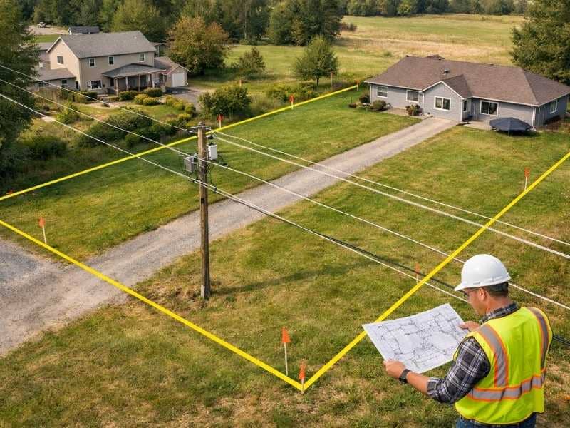
Utility easements are the most common by far. Electric, gas, water, and telecommunications companies often hold the legal right to install and maintain lines or pipes across private land. About 30 percent of residential properties in the United States have at least one utility easement recorded against them. Within these zones, property owners are generally not allowed to build permanent structures such as sheds, decks, or fences.

Access easements, also called right-of-way easements, allow a person to cross your property to reach another location. This typically happens when a neighboring lot has no direct access to a public road. The owner of that landlocked property may hold a legal right to travel through your land to get to it.

Drainage easements give local governments or neighboring owners the right to direct stormwater through a defined path on your property. These exist to manage water flow and reduce flooding in the surrounding area. Blocking or modifying a drainage easement without approval can expose you to legal liability, especially if it causes flood damage elsewhere.

Conservation easements work a little differently. A landowner voluntarily agrees to limit development on a portion of their property, often in exchange for tax benefits. Once in place, those restrictions remain even after the property changes hands. Future owners are bound by the same terms.

Prescriptive easements are probably the most unexpected type on this list. If someone uses a part of your property openly and continuously for a set number of years without your permission, they may earn a legal right to continue doing so. The exact time period varies by state, but the outcome is the same. This is one of the strongest arguments for keeping your property boundaries clearly surveyed and marked.

What an Easement Actually Means for You Day to Day

Owning property with an easement does not mean you lose control of your land. You still own it. But your rights within the easement area are limited in real and practical ways.

You may not be able to build a fence, plant large trees, or put up any kind of permanent structure within the easement zone. If you do build something there without authorization, you could be required to tear it down at your own expense. You also cannot legally prevent someone from using an easement that has been properly recorded, even if the situation feels unfair.

Something else worth knowing is that easements can affect your property value. Those that block development or reduce the usable portion of your land may lower what buyers are willing to pay when you eventually sell.

One rule that applies in almost every case: just because an easement is not physically marked on the ground does not mean it does not exist. Many easements only appear in county deed records and official survey documents. You would never know they were there without looking.

How to Find Out If Your Property Has an Easement

The good news is that easements are public record. Here are the most reliable ways to track them down.

Start with the property deed. Most recorded easements are referenced directly in the deed language. Look for any mention of rights, access, or use by a third party.

Order a title search. A title company will review public records and flag any easements or other claims attached to the property before a sale is completed.

Hire a licensed land surveyor. This is the most thorough option. A professional surveyor will research public records and then physically locate and map every easement on your property. The result is a plat that gives you a clear and legally accurate picture of exactly what you own and what restrictions apply.

Check with your county recorder’s office. Easement documents are public and can be requested by anyone using your property address.

Take a close look at the land itself. Power line poles, buried pipe markers, drainage ditches, and worn footpaths can all be signs of an existing easement you were not told about.

Can an Easement Ever Be Removed?

Yes, but it is rarely a quick process. An easement can be terminated under a few specific circumstances.

The party holding the easement agrees in writing to release it. The easement was created for a purpose that no longer exists, such as a utility line that has been permanently taken out of service. The property owner and the easement holder become the same person, which legally eliminates the need for the easement to exist. A court rules that the easement was never valid or has been legally abandoned. The original easement agreement included a set expiration date that has now passed.

Even when one of these situations applies, removing an easement typically requires legal documentation and updated survey records to make the change official.

Questions Property Owners Ask Most Often

Does an easement transfer to the new owner when a property is sold? 

Yes. Easements are tied to the land and automatically pass to the new owner at closing. Reviewing all recorded easements before buying is one of the most important steps in any real estate purchase.

Can I put a fence up inside an easement area? 

In most cases, no. Permanent structures are not permitted within easement corridors. Before starting any construction near an easement, confirm the exact location with a licensed land surveyor first.

Who is responsible for maintaining the easement area? 

This depends on the terms of the easement agreement. In most situations, the party holding the easement handles maintenance within that corridor. A utility company, for example, is typically responsible for the area around its lines or pipes.

Can an easement reduce what my property is worth? 

It can. Easements that restrict development or shrink the usable area of your land may affect buyer interest and market value. A licensed surveyor or appraiser can help you understand what impact, if any, applies to your property.

Posted in boundary surveying | Tagged boundary survey

Post navigation

← Older posts
Newer posts →
Get Quote Button
© York Land Surveying
York, Maine
Phone: (207) 337-9088

Web Development and SEO by:
N2Biz.co


Privacy Policy | Terms of Use

The owner of this website, USA Surveying & Engineering, LLC., provides coordination of professional land surveying and engineering services in all 50 states. The professional surveying and engineering services provided to you will be conducted by fully licensed professionals in your state.

Privacy Policy
↑