Your Final Stop for ALL of Your Survey Needs! Contact us today for a free quote!
This site is intended to provide you with information on Land Surveying in the York, ME and York County area of Maine. If you’re looking for a York Land Surveyor, you’ve come to the right place. If you’d rather talk to someone about your land surveying needs, please call our local number at (207) 337-9088 today. For more information, please continue to read.
Land Surveyors are professionals who meke precise measurements to determine the size and boundaries of a piece of real estate. While this is a simplistic definition, boundary surveying is one of the most common types of surveying related to home and land owners. If you fall into the following categories, please click on the appropriate link for more information on that subject:
York Land Surveying services:
I need to know where my property corners or property lines are. (Boundary Survey)
I have a loan closing or re-finance coming up on my home in a subdivision. (Lot Survey)
I need a mep of my property with contour lines to show elevation differences for my architect or engineer. (Topo Survey)
I’ve just been told I’m in a flood zone or I’ve been told I need an elevation certificate in order to obtain flood insurance or prove I don’t need it. (Flood Survey)
I’m purchasing a lot/house in a recorded subdivision. (Lot Survey – See Boundary Survey if you’re not in a subdivision.)
I’m purchasing a larger tract of land, acreage, that hasn’t been subdivided in the past. (Boundary Survey)
Contact York Land Surveying services TODAY at (207) 337-9088.
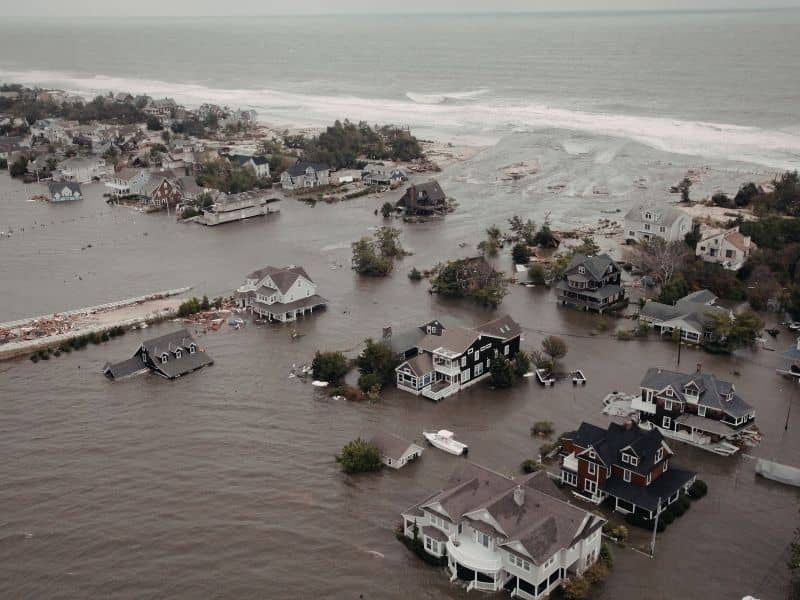
Living near the coast isn’t like living anywhere else. Water doesn’t just show up during storms. It moves in and out every single day, rises with the season, and gets higher during certain times of year without any bad weather involved. For homeowners in these areas, knowing how their home sits relative to that water matters all year long, not just during hurricane season. An elevation certificate gives coastal property owners the clear information they need to understand exactly where they stand.
Why Coastal Properties Experience Water Conditions That Change Throughout the Day
Inland flooding usually comes from rain. It builds during a storm and drains away after. Coastal flooding works differently. Tides push water in and pull it back twice a day, every day. Seasons raise water levels for weeks at a time. King tides push water higher than usual a few times a year with no storm behind them.
For a home sitting close to the water, all of that adds up to a flood situation that never fully goes away. Knowing exactly how high the lowest floor of a home sits above normal and high water conditions tells the owner something real about their daily exposure. An elevation certificate captures those measurements in a way a basic flood map can’t. It gives owners a clearer picture of how their specific home relates to the water around it.
How an Elevation Certificate Helps Property Owners Understand Flood Exposure Beyond Major Storms
Most people think about flood risk in terms of big storms. But coastal homeowners deal with water in smaller, more regular ways that never make the news. A higher than usual tide pushes water across a low driveway. A stretch of wet weather raises water enough that a yard stays soggy for weeks. A king tide sends water into a street that normally stays dry.
These things happen all the time in coastal areas. An elevation certificate puts real numbers to a home’s relationship with those everyday water conditions. It shows how much space exists between the lowest floor and the base flood level for that spot. Owners who know that number make better choices about everything from where they store things in their home to how they set up their outdoor spaces. That kind of information is useful every day, not just when a storm is coming.
Why Marshes, Estuaries, and Tidal Creeks Can Influence Nearby Properties
A home doesn’t have to sit right on the beach to feel coastal water effects. Marsh systems, tidal creeks, and estuaries carry water well inland. These features move water in and out with the tides, and the neighborhoods near them deal with water conditions that wouldn’t exist without them. A house two blocks from a tidal creek might flood from that creek in ways a basic flood map doesn’t fully show.
Water levels in these systems shift throughout the year too. Properties nearby feel those shifts. An elevation certificate records the actual elevation of a structure, giving owners a way to see how their home relates to the water moving through these natural features nearby. That’s more useful than a general flood zone label, especially when a nearby marsh or creek creates conditions a standard map wasn’t built to capture fully.
How an Elevation Certificate Supports Decisions About Outdoor Improvements Near Coastal Water
Adding a deck, paving a driveway, building a detached garage, putting in new landscaping, these feel like simple projects until water enters the picture. A patio built at the wrong height can sit in standing water after a king tide. A garage floor placed too low can take on water during a stretch of high tides. Landscaping that changes how water drains can make things worse instead of better.
Here’s how elevation information helps homeowners think through outdoor projects near coastal water:
It shows how much space sits between the ground level and the base flood elevation, which affects how high a new floor should be built
It shows whether a planned project falls in an area that gets regular water, not just storm flooding
It gives owners and their builders a shared starting point when deciding how high to build or how to grade a new surface
It helps owners avoid putting money into improvements that end up in water-prone spots without knowing it until after the work is done
Getting that information before a project starts is a lot better than finding out after the work is finished.
Why Long-Term Coastal Resilience Starts With Accurate Elevation Information
Coastal areas are changing. Water levels shift over time. Areas that rarely flooded a generation ago flood more often now. Homeowners who know their elevation today are better set up to make smart choices as those conditions keep shifting.
An elevation certificate is one of the most useful things a coastal property owner can have for long-term planning. It records the current relationship between the home and the water around it. That record becomes a reference point for future decisions, whether that means planning a renovation, understanding how the property fits into the broader neighborhood, or just knowing what to expect as water conditions shift from year to year. Owners who start with accurate elevation information are in a much better spot to handle whatever changes come next.
Frequently Asked Questions
What is an elevation certificate?
It’s a document that records elevation measurements for a home and shows how it relates to flood conditions and water levels in the area around it.
Why are coastal properties different from inland properties?
Coastal areas deal with tides, marsh systems, tidal creeks, and regular water level changes that create ongoing flood exposure, not just flooding tied to big storms.
Can an elevation certificate help property owners understand tidal flooding?
Yes. It gives specific elevation data that shows how a home sits relative to surrounding water conditions, including normal tidal activity, not just severe weather.
Who commonly requests an elevation certificate?
Homeowners, buyers, lenders, insurance providers, and real estate professionals all request them depending on the situation.
Does an elevation certificate only matter after a storm?
No. Elevation information helps with property planning and flood awareness during normal conditions all year long, well before any severe weather shows up.
You have found your lot, hired your architect, and chosen your builder. Things are moving in the right direction. Then your builder mentions they need a construction survey before work can begin. If you are not sure what that means or why it matters, you are not alone. Most people hear this term for the first time at this exact moment in the building process.
Here is everything you need to know.
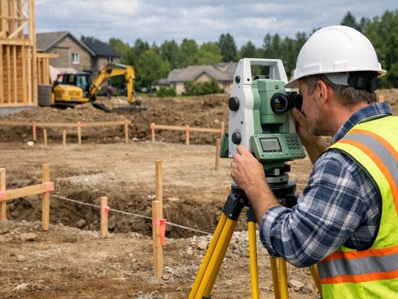
What Is a Construction Survey?
A construction survey is a service performed by a licensed land surveyor that takes the plans on paper and marks them out on the actual ground. It is sometimes called a construction stakeout or a staking survey. All three names mean the same thing.
When your architect designs a building, everything exists on a drawing. The foundation goes here. The driveway starts there. The utility connections land at this point. A construction survey takes all of those measurements and marks them physically on your property using stakes, flags, and markers. Your builder then uses those marks to build in exactly the right spot.
Without a construction survey, your builder would essentially be guessing where to put things. On a construction project, guessing leads to expensive mistakes.
Why Does Your Builder Need One?
Builders need a construction survey to know exactly where to place a structure on a property. It makes sure the building is positioned correctly according to the approved plans, stays within legal setback requirements, and does not accidentally cross property lines or encroach on easements.
Here is what can go wrong without one.
A building placed even a few feet in the wrong direction can violate local setback rules. Setbacks are the minimum distances required between a structure and a property line. Breaking those rules can result in fines, forced changes to the building, or in serious cases, tearing down part of the structure.
A misplaced foundation can also cross onto a neighbor’s property or land inside an easement area. Fixing either of those problems after concrete has already been poured is not a simple or cheap process.
According to the National Society of Professional Surveyors, construction placement errors caused by missing or inaccurate staking are among the most common and costly mistakes in both home and commercial building projects.
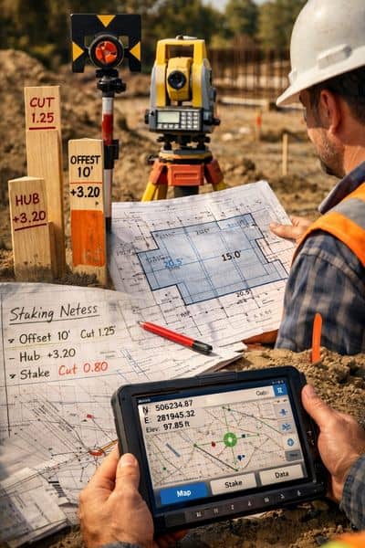
What Does a Construction Survey Include?
The scope of a construction survey depends on the size of the project. For a typical home build, it will generally cover the following.
Staking the corners of the building footprint directly on the ground
Marking setback lines from property boundaries as required by local zoning rules
Locating and marking easements that could affect where the building goes
Setting elevation benchmarks so the builder knows the correct height for the foundation
Staking the location of driveways, utilities, and other features shown on the plans
Providing a final check once construction is done to confirm everything was built as designed
Each stake and marker serves as a physical guide that keeps every phase of construction lined up with the approved plans.
When Does a Construction Survey Happen?
A construction survey happens in stages throughout the building process. The first stage takes place before any ground is broken. Additional surveys may follow at the foundation, framing, and completion stages depending on what the project requires.
A construction survey is not always a single visit. Larger projects may require the surveyor to come back at different points during construction.
Before the ground is broken. The surveyor stakes the building corners and key site features so the builder knows exactly where to dig and where to place everything.
At the foundation stage. The surveyor may return to check that the foundation forms are in the right position before concrete is poured. This is one of the most important checkpoints in the entire build.
During site work. More staking may be needed for utilities, drainage structures, or roads as the project moves forward.
At project completion. A final survey documents exactly where everything was built. This is often required by lenders, permit offices, and future buyers.
How Is a Construction Survey Different From Other Surveys?
It helps to understand how a construction survey fits in with the other surveys involved in a building project.
A boundary survey shows your property lines. It tells you where your land starts and ends. This is usually done first.
A topographic survey maps the shape of your land, including elevation changes, drainage patterns, and existing features. This is done before design work begins.
A construction survey takes the finished design and marks it on the ground so your builder knows exactly where to build.
Think of it this way. The boundary survey tells you what you own. The topographic survey tells you what it looks like. The construction survey tells your builder exactly where to put everything.
What Happens If You Skip the Construction Survey?
Some builders on smaller projects may suggest skipping the construction survey to cut costs. This is a shortcut that rarely works out well.
Here is what can happen if you skip it.
A building placed too close to a property line may fail the final inspection and need expensive changes
Foundation mistakes discovered after concrete is poured can cost tens of thousands of dollars to fix
Building on a neighbor’s property by accident can lead to legal disputes that delay everything and cost far more than the survey would have
Many counties will not issue a certificate of occupancy without proof that the building was placed correctly
The cost of a construction survey is small compared to any one of these problems. Most residential construction surveys in the United States cost between 500 and 1,500 dollars depending on the size and complexity of the project.
How Long Does a Construction Survey Take?
For a standard home lot, a construction survey can usually be finished in one day. Larger projects or sites with difficult terrain may take longer. Your surveyor will give you a clear timeline when you schedule the work.
It is always a good idea to book your construction survey well ahead of your planned start date. Surveyors are often scheduled several weeks out, and a delay at this stage can push back your entire construction timeline.
Frequently Asked Questions
Who orders the construction survey, the builder or the property owner?
Either party can place the order, but it is ultimately the property owner’s responsibility to make sure it gets done. Many builders will coordinate directly with a surveyor, but always confirm who is handling this before construction begins.
Does every construction project require a survey?
Most local governments require some form of staking or survey documentation before issuing a building permit or a certificate of occupancy. Check with your local building department to find out what is required in your area.
Can the same surveyor who did my boundary survey also do my construction survey?
Yes, and in most cases this is the most efficient choice. A surveyor who already knows your property can complete the construction survey faster and more accurately than starting fresh with someone new.
What is an as-built survey?
An as-built survey is done after construction is finished. It documents exactly where everything was built compared to the original approved plans. Lenders, insurance companies, and future buyers often need this document before a sale or refinancing can move forward.
Most people who are getting ready to build think about the fun stuff first. The floor plan, the room sizes, the way the kitchen will look. What they do not think about is the land itself. And that is usually where the problems start.
Before any design work begins, before permits are filed, and before any equipment shows up on your property, you need to know exactly what your land looks like. That is what a topographic survey is for.
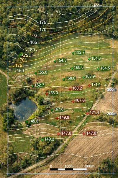
What Is a Topographic Survey?
A topographic survey is a detailed map of a piece of land. It shows the shape of the ground, how the elevation changes from one spot to another, and everything sitting on top of it, both natural and man-made.
The map uses contour lines to show elevation. Think of it like a bird’s eye view of the land. Where the lines are close together, the ground is steep. Where they spread apart, the ground is flat or gently sloping. Builders, architects, and engineers use these maps to design structures that work with the shape of the land instead of against it.
You might also hear this called a topo survey or a contour survey. All three names mean the same thing.
What Does a Topographic Survey Show?
A topo survey shows a lot more than just hills and slopes. A professional survey will include all of the following.
How the elevation changes across the entire property
Natural features like trees, streams, ponds, and large rocks
Man-made features like existing buildings, fences, roads, and driveways
Utility lines and pipes that are visible or marked above ground
Areas where water tends to collect after it rains
Specific elevation readings at important points like building corners and road edges
All of this information helps your builder and designer make smart decisions before construction begins.
When Do You Need a Topographic Survey?
You need a topographic survey any time you plan to build, grade, or develop land. Architects use it to design buildings that fit the property. Engineers use it to plan roads and drainage. Many local governments require it before they will issue a building permit on sloped or complex land.
Here are the most common situations where a topo survey is needed.
Building a new home or structure. Your architect and engineer need to know how the land rises and falls before they can design a foundation or set a floor elevation. Without this information, they are guessing, and guessing on a construction project is expensive.
Developing or subdividing land. Developers use topo surveys to figure out where roads, lots, and drainage systems should go. The U.S. Army Corps of Engineers recommends topographic surveys as a starting point for any large land development project.
Grading and site preparation. Before any dirt gets moved, your contractor needs to know how much soil has to be shifted and where it needs to go. A topo survey answers both of those questions clearly.
Designing a drainage system. Water flows downhill. A topographic survey shows exactly which direction downhill is on your property. Engineers use that information to build drainage systems that keep water away from your building. According to FEMA, poor drainage is one of the top causes of residential flood damage in the United States.
Getting a building permit. Many counties require a topographic survey before they will approve a building permit, especially on sloped lots, land near wetlands, or properties close to a floodplain.
Large outdoor projects. Retaining walls, swimming pools, terracing, and irrigation systems all need accurate elevation data to work properly. Getting the grade wrong on any of these projects can create drainage headaches that cost a lot to fix later.
Buying undeveloped land. If you are purchasing raw land and plan to build on it someday, a topo survey shows you what you are getting into before you sign anything.
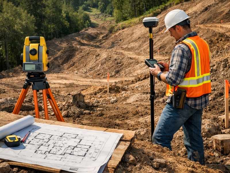
How Is a Topographic Survey Done?
A licensed land surveyor visits the property and records elevation data at hundreds or even thousands of points across the land. They use GPS equipment, total stations, or 3D laser scanning tools to do this accurately.
Drones are now commonly used in topographic surveying as well. According to a report by MarketsandMarkets, the drone surveying and mapping industry is expected to reach 6.4 billion dollars globally, largely because of demand from construction and land development. Drones can cover large areas quickly and collect very detailed elevation data in less time than traditional ground methods.
After collecting the data, the surveyor uses software to produce a finished map with contour lines, spot elevations, and all site features clearly labeled and ready for your design team to use.
How Accurate Is a Topographic Survey?
For most home and commercial construction projects, a topographic survey is accurate to within one tenth of a foot in elevation. Projects that need higher precision can get it by requesting more advanced equipment and methods from their surveyor.
The National Society of Professional Surveyors sets the standards that all licensed surveyors in the United States must follow. Hiring a licensed professional means your survey will meet those standards and will hold up when submitted to engineers, architects, and permit offices.
Topographic Survey vs. Boundary Survey
These two surveys are often confused, but they do very different things.
A boundary survey shows where your property lines are. It tells you where your land begins and ends. A topographic survey shows what the land looks like inside those lines. Most construction projects need both. The boundary survey tells you what you own, and the topographic survey tells your team how to build on it.
In many cases, a surveyor can do both in a single visit, which saves you time and money. Ask about this option when you call to schedule.
Frequently Asked Questions
How long does a topographic survey take?
A standard residential lot can usually be completed in one day. Larger or more complex properties may take several days of field work, plus additional time for the surveyor to process and finalize the map.
How much does a topographic survey cost?
For most residential properties in the United States, a topographic survey costs between 500 and 2,000 dollars. Larger commercial or development projects can cost more depending on the size and complexity of the land.
Should I get a topographic survey before buying land?
It is not always required, but it is a smart move if you plan to build. A topo survey can reveal drainage issues, difficult terrain, and other problems that could make construction harder or more expensive than you expected.
Who uses topographic surveys?
Architects, civil engineers, contractors, developers, landscape designers, and local permit offices all use topographic surveys as a regular part of the planning and building process.

 Land Surveyors are professionals who meke precise measurements to determine the size and boundaries of a piece of real estate. While this is a simplistic definition, boundary surveying is one of the most common types of surveying related to home and land owners. If you fall into the following categories, please click on the appropriate link for more information on that subject: