
Planning to Build? Here Is Why a Topographic Survey Should Be Your First Step.
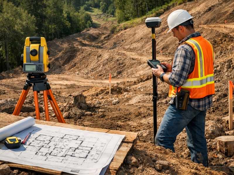
Most people who are getting ready to build think about the fun stuff first. The floor plan, the room sizes, the way the kitchen will look. What they do not think about is the land itself. And that is usually where the problems start.
Before any design work begins, before permits are filed, and before any equipment shows up on your property, you need to know exactly what your land looks like. That is what a topographic survey is for.
What Is a Topographic Survey?
A topographic survey is a detailed map of a piece of land. It shows the shape of the ground, how the elevation changes from one spot to another, and everything sitting on top of it, both natural and man-made.
The map uses contour lines to show elevation. Think of it like a bird’s eye view of the land. Where the lines are close together, the ground is steep. Where they spread apart, the ground is flat or gently sloping. Builders, architects, and engineers use these maps to design structures that work with the shape of the land instead of against it.
You might also hear this called a topo survey or a contour survey. All three names mean the same thing.
What Does a Topographic Survey Show?
A topo survey shows a lot more than just hills and slopes. A professional survey will include all of the following.
- How the elevation changes across the entire property
- Natural features like trees, streams, ponds, and large rocks
- Man-made features like existing buildings, fences, roads, and driveways
- Utility lines and pipes that are visible or marked above ground
- Areas where water tends to collect after it rains
- Specific elevation readings at important points like building corners and road edges
All of this information helps your builder and designer make smart decisions before construction begins.
When Do You Need a Topographic Survey?
You need a topographic survey any time you plan to build, grade, or develop land. Architects use it to design buildings that fit the property. Engineers use it to plan roads and drainage. Many local governments require it before they will issue a building permit on sloped or complex land.
Here are the most common situations where a topo survey is needed.
Building a new home or structure. Your architect and engineer need to know how the land rises and falls before they can design a foundation or set a floor elevation. Without this information, they are guessing, and guessing on a construction project is expensive.
Developing or subdividing land. Developers use topo surveys to figure out where roads, lots, and drainage systems should go. The U.S. Army Corps of Engineers recommends topographic surveys as a starting point for any large land development project.
Grading and site preparation. Before any dirt gets moved, your contractor needs to know how much soil has to be shifted and where it needs to go. A topo survey answers both of those questions clearly.
Designing a drainage system. Water flows downhill. A topographic survey shows exactly which direction downhill is on your property. Engineers use that information to build drainage systems that keep water away from your building. According to FEMA, poor drainage is one of the top causes of residential flood damage in the United States.
Getting a building permit. Many counties require a topographic survey before they will approve a building permit, especially on sloped lots, land near wetlands, or properties close to a floodplain.
Large outdoor projects. Retaining walls, swimming pools, terracing, and irrigation systems all need accurate elevation data to work properly. Getting the grade wrong on any of these projects can create drainage headaches that cost a lot to fix later.
Buying undeveloped land. If you are purchasing raw land and plan to build on it someday, a topo survey shows you what you are getting into before you sign anything.
How Is a Topographic Survey Done?
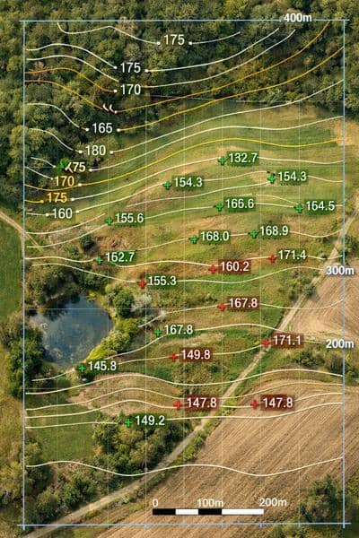
A licensed land surveyor visits the property and records elevation data at hundreds or even thousands of points across the land. They use GPS equipment, total stations, or 3D laser scanning tools to do this accurately.
Drones are now commonly used in topographic surveying as well. According to a report by MarketsandMarkets, the drone surveying and mapping industry is expected to reach 6.4 billion dollars globally, largely because of demand from construction and land development. Drones can cover large areas quickly and collect very detailed elevation data in less time than traditional ground methods.
After collecting the data, the surveyor uses software to produce a finished map with contour lines, spot elevations, and all site features clearly labeled and ready for your design team to use.
How Accurate Is a Topographic Survey?
For most home and commercial construction projects, a topographic survey is accurate to within one tenth of a foot in elevation. Projects that need higher precision can get it by requesting more advanced equipment and methods from their surveyor.
The National Society of Professional Surveyors sets the standards that all licensed surveyors in the United States must follow. Hiring a licensed professional means your survey will meet those standards and will hold up when submitted to engineers, architects, and permit offices.
Topographic Survey vs. Boundary Survey
These two surveys are often confused, but they do very different things.
A boundary survey shows where your property lines are. It tells you where your land begins and ends. A topographic survey shows what the land looks like inside those lines. Most construction projects need both. The boundary survey tells you what you own, and the topographic survey tells your team how to build on it.
In many cases, a surveyor can do both in a single visit, which saves you time and money. Ask about this option when you call to schedule.
Frequently Asked Questions
How long does a topographic survey take?
A standard residential lot can usually be completed in one day. Larger or more complex properties may take several days of field work, plus additional time for the surveyor to process and finalize the map.
How much does a topographic survey cost?
For most residential properties in the United States, a topographic survey costs between 500 and 2,000 dollars. Larger commercial or development projects can cost more depending on the size and complexity of the land.
Should I get a topographic survey before buying land?
It is not always required, but it is a smart move if you plan to build. A topo survey can reveal drainage issues, difficult terrain, and other problems that could make construction harder or more expensive than you expected.
Who uses topographic surveys?
Architects, civil engineers, contractors, developers, landscape designers, and local permit offices all use topographic surveys as a regular part of the planning and building process.