
Why an Elevation Certificate Matters More for Properties Influenced by Tidal Water and Coastal Flooding
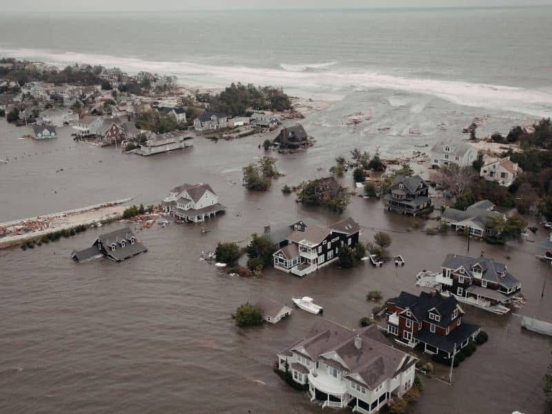
Living near the coast isn’t like living anywhere else. Water doesn’t just show up during storms. It moves in and out every single day, rises with the season, and gets higher during certain times of year without any bad weather involved. For homeowners in these areas, knowing how their home sits relative to that water matters all year long, not just during hurricane season. An elevation certificate gives coastal property owners the clear information they need to understand exactly where they stand.
Why Coastal Properties Experience Water Conditions That Change Throughout the Day
Inland flooding usually comes from rain. It builds during a storm and drains away after. Coastal flooding works differently. Tides push water in and pull it back twice a day, every day. Seasons raise water levels for weeks at a time. King tides push water higher than usual a few times a year with no storm behind them.
For a home sitting close to the water, all of that adds up to a flood situation that never fully goes away. Knowing exactly how high the lowest floor of a home sits above normal and high water conditions tells the owner something real about their daily exposure. An elevation certificate captures those measurements in a way a basic flood map can’t. It gives owners a clearer picture of how their specific home relates to the water around it.
How an Elevation Certificate Helps Property Owners Understand Flood Exposure Beyond Major Storms
Most people think about flood risk in terms of big storms. But coastal homeowners deal with water in smaller, more regular ways that never make the news. A higher than usual tide pushes water across a low driveway. A stretch of wet weather raises water enough that a yard stays soggy for weeks. A king tide sends water into a street that normally stays dry.
These things happen all the time in coastal areas. An elevation certificate puts real numbers to a home’s relationship with those everyday water conditions. It shows how much space exists between the lowest floor and the base flood level for that spot. Owners who know that number make better choices about everything from where they store things in their home to how they set up their outdoor spaces. That kind of information is useful every day, not just when a storm is coming.
Why Marshes, Estuaries, and Tidal Creeks Can Influence Nearby Properties
A home doesn’t have to sit right on the beach to feel coastal water effects. Marsh systems, tidal creeks, and estuaries carry water well inland. These features move water in and out with the tides, and the neighborhoods near them deal with water conditions that wouldn’t exist without them. A house two blocks from a tidal creek might flood from that creek in ways a basic flood map doesn’t fully show.
Water levels in these systems shift throughout the year too. Properties nearby feel those shifts. An elevation certificate records the actual elevation of a structure, giving owners a way to see how their home relates to the water moving through these natural features nearby. That’s more useful than a general flood zone label, especially when a nearby marsh or creek creates conditions a standard map wasn’t built to capture fully.
How an Elevation Certificate Supports Decisions About Outdoor Improvements Near Coastal Water
Adding a deck, paving a driveway, building a detached garage, putting in new landscaping, these feel like simple projects until water enters the picture. A patio built at the wrong height can sit in standing water after a king tide. A garage floor placed too low can take on water during a stretch of high tides. Landscaping that changes how water drains can make things worse instead of better.
Here’s how elevation information helps homeowners think through outdoor projects near coastal water:
- It shows how much space sits between the ground level and the base flood elevation, which affects how high a new floor should be built
- It shows whether a planned project falls in an area that gets regular water, not just storm flooding
- It gives owners and their builders a shared starting point when deciding how high to build or how to grade a new surface
- It helps owners avoid putting money into improvements that end up in water-prone spots without knowing it until after the work is done
Getting that information before a project starts is a lot better than finding out after the work is finished.
Why Long-Term Coastal Resilience Starts With Accurate Elevation Information
Coastal areas are changing. Water levels shift over time. Areas that rarely flooded a generation ago flood more often now. Homeowners who know their elevation today are better set up to make smart choices as those conditions keep shifting.
An elevation certificate is one of the most useful things a coastal property owner can have for long-term planning. It records the current relationship between the home and the water around it. That record becomes a reference point for future decisions, whether that means planning a renovation, understanding how the property fits into the broader neighborhood, or just knowing what to expect as water conditions shift from year to year. Owners who start with accurate elevation information are in a much better spot to handle whatever changes come next.
Frequently Asked Questions
What is an elevation certificate?
It’s a document that records elevation measurements for a home and shows how it relates to flood conditions and water levels in the area around it.
Why are coastal properties different from inland properties?
Coastal areas deal with tides, marsh systems, tidal creeks, and regular water level changes that create ongoing flood exposure, not just flooding tied to big storms.
Can an elevation certificate help property owners understand tidal flooding?
Yes. It gives specific elevation data that shows how a home sits relative to surrounding water conditions, including normal tidal activity, not just severe weather.
Who commonly requests an elevation certificate?
Homeowners, buyers, lenders, insurance providers, and real estate professionals all request them depending on the situation.
Does an elevation certificate only matter after a storm?
No. Elevation information helps with property planning and flood awareness during normal conditions all year long, well before any severe weather shows up.